Computer Vision for Urban Regeneration
Iacopo Testi, Advisor and Contributor of Urban AI, is an italian urban technologist and data scientist. His professional and academic interests revolve around the development and applications of data science methodologies to transform urban environments into sustainable and seanseable cities.
Street view imagery might constitute a key resource to analyze and monitor our urban areas. Moreover, the emergence of artificial intelligence allows to inspect image data with accuracy and speed that were previously unthinkable. In the following article it is presented a compendium of the research [1], conducted by University of Cambridge and Tsinghua University researchers, that presents computer vision models applied to street level image data.
Available data on building’s conditions is crucial for city planning departments to define strategies and guidelines for urban management and renewal [2]. However, detailed buildings census are costly in terms of economic resources and time. Therefore, the study proposes artificial intelligence models to predict physical qualities from urban scenery such as facades construction type, maintenance and continuity.
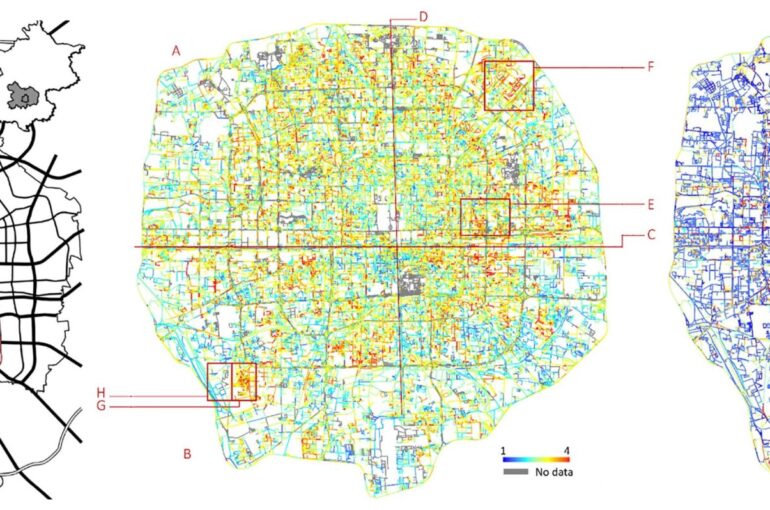
The study area selected for the research proposition is Beijing and specifically the site within the 5th ring road, which covers approximately 670 km2, where resides around 10.54 million people. The 360.796 images (800 x 500 pixels) utilized for the investigation are obtained from Baidu Map [3], the Chinese equivalent of Google Map, collected at an interval of 200 meters along all the streets of the city, in February 2016.

The aforementioned data are randomly sampled and manually labeled as ‘building images’ (2575) and ‘street images’ (925). Afterward, the first artificial qualification model is applied on all visual data to select only the ones containing buildings. Subsequently, the images selected by the first model are labeled through expert rating on the attributes considered in the research : construction, maintenance quality and street wall continuity (see fig.1). Finally, the second artificial intelligence model, composed of a convolutional neural network [4] combined with a support vector regression [5], is trained and all urban scenery attributes are classified.
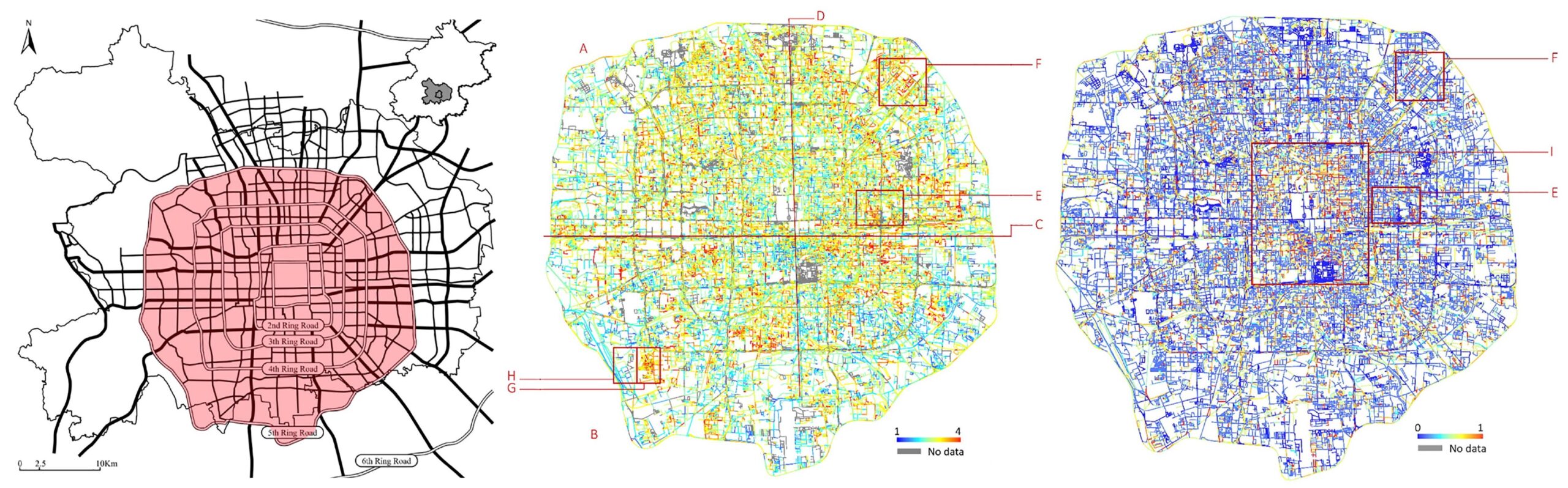
The two artificial neural network models display high performances for qualification and visual continuity, respectively 90 and 75 percent accuracy. Additionally, the figure above shows the inference performed on all images at city scale, identifying different urban patterns. For instance, in terms of visual quality, the northern part of the city (Zone A) generally scores higher than the southern part (Zone B), especially at the urban fringes between the 4th and the 5th ring roads. Therefore, this indicates that greater emphasis might be given to the southern city in the agenda of urban renewal, which could involve a range of measures from removing stains on the facade to overall façade improvement or demolition and reconstruction of very degraded structures.
Finally, the investigation reveals the perspective of computer vision and convolutional neural networks to support city planning departments and policy-makers. Specifically, having a comprehensive understanding of the urban built environment can assist urban renewal, neighborhood revitalization, cultural heritage preservation and socio-economic investigations. Concluding, if we only think about the outskirts and suburban areas of our biggest cities we can easily comprehend the indubitable potential of intelligent automation methodologies applied to the city planning domain.
By Iacopo Testi
References
[1] Lun Liu, Elisabete A. Silva, Chunyang Wu, HuiWang (2017). A machine learning-based method for the large-scale evaluation of the qualities of the urban environment. https://www.sciencedirect.com/science/article/pii/S0198971516301831
[2] Lynch, K.(1960). The Image of the city. MIT Press.
[3] Baidu Map website. https://map.baidu.com
[4] Christian Szegedy, Wei Liu, Yangqing Jia, Pierre Sermanet, Scott Reed, Dragomir Anguelov, Dumitru Erhan, Vincent Vanhoucke, Andrew Rabinovich (2014). Going Deeper with Convolutions. https://arxiv.org/abs/1409.4842
[5] Mariette AwadRahul Khanna (2015). Support Vector Regression. https://link.springer.com/chapter/10.1007/978-1-4302-5990-9_4
This article is also available on our Medium : https://medium.com/urban-ai/computer-vision-for-urban-regeneration-dca4594f6317
